Part 1 of 3
Unchecked urbanization and globalization have corralled humanity into cities and into a state of near-total dependence. Everything city dwellers need to live is shipped to cities, often from the other countries or continents in exchange for dollars backed by a combination of faith and fear. Faith that they are worth what the government says they are worth, and fear of the global financial collapse that will occur if enough people realize overprinting and inflation have caused them to lose too much value too fast. If banking, the power grid, the Internet, or global transportation slows too much, the house of cards will collapse, and people will once again fight over food, water, fuel, medicine, and weapons.
In such times, staying in the city is certain death, as it is in a dozen more scenarios. History abounds with examples of disasters, both manmade and natural, where migration promised far better chances of survival than staying put.

So, what must the survivor consider when foot travel is necessary for migration, escape and evasion, security, to “Get off the ‘X’”, to obtain resources, or for other purposes?
Lines of Drift & Chokepoints
Lines of drift are roads, trails, fence lines, rivers, ridges, washes, riverbeds. They are the path of least resistance and are therefore the paths that both man and animals most often tread. We walk on roads or trails and avoid obstacles and bushwhacking cross country to conserve energy. Some cities have freeways that ring them. Control the ring and everything inside it becomes a prison.
Chokepoints are intersections, bridges, and narrow canyons that bottleneck traffic into a small area that can be controlled with less manpower and fewer weapons. In cities checkpoints are set on highways in and out of town, at key intersections, and near installations that must be controlled such as airports, military bases, hospitals, centers of government, and so on.
Stay off Lines of Drift and Away from Chokepoints
Since people and animals travel along lines of drift, they are where ambushes and checkpoints occur. No organization has unlimited resources and setting an ambush or checkpoint requires manpower, weapons, ammunition, and other supplies so ambushes and checkpoints are most often set where they are most effective. If the objective is stealing lots of portable wealth and food, ambushes are going to be set on major roads where they have and advantage and can get away with it. If the goal is to control the population, checkpoints will be setup at intersections, crossroads, ring roads, and roads in and out of town. These locations should be avoided even though it creates work.
When society is stressed, it fractures along lines of politics, religion, ethnicity, or economics. The pretense of an ambush or checkpoint could be anything from security to war, banditry, political or ethnic cleansing, to straight up genocide.
Roadblocks are thrown up. Travelers are stopped and asked for ID which his compared to databases on laptop computers. Persons from the wrong political party, religion, tribe, race, or economic class, are shot on the spot.
The lucky ones are hauled off to work camps where their DNA and biometrics will be taken, and then they will be sterilized and brainwashed if they aren’t injected with anticoagulants and killed for their organs because some loyalist needs a kidney.
In any case, nothing good is likely to come from walking into an ambush or getting stopped at a post-apocalyptic checkpoint.
Getting Out of Cities
Decisionmakers are often driven by fear in emergencies. This can make it difficult to get out of a city, even on foot. During Hurricane Katrina, some of the surrounding parishes were afraid that refugees would tear through their parishes like army ants, devouring or stealing everything that wasn’t nailed down, so, instead of helping their fellow citizens, they directed their sheriff’s departments to setup roadblocks that effectively imprisoned refugees in the flooded and badly damaged city, creating a manmade humanitarian crisis on top of a natural disaster.
To improve your chances of getting out of your city, identify the ways out. We normally travel on the roads, so they are what we know, but lakes, rivers, canals, rainwater drainage tunnels and channels, park systems, farmland, mountain ranges, nature preserves, bike trails, power lines, pipelines, and rail lines can provide additional routes out of town. Observe these features, their rights of way, and any fences, locks, manhole covers, or other obstacles to accessing them. Then make a plan and gather the tools and resources you’ll need.
I planned a route out of a city when I lived in one. I would have had to climb or knock down a cinderblock wall, lift a manhole cover and climb down into a drainage tunnel, walk through that tunnel to a grate where it emptied into a riverbed, which I could take out of town. I devised a way over the fence, gathered some large military smoke munitions to lay down smoke to screen the exposed manhole cover, made a tool to lift the manhole cover, and tools to deal with locks in case someone locked the grate. I explored the drainage system to make sure it was clear and explored my route out of the city. It was in the desert, so I identified year-round water sources, hide sites, and hole up areas and cached supplies along the route to my bugout location.
I knew my prospects of competing with millions of others for the scant resources the desert provides were not great and eventually relocated out of the city to a less densely populated place where I felt it would be easier to survive the next time the world goes sideways.
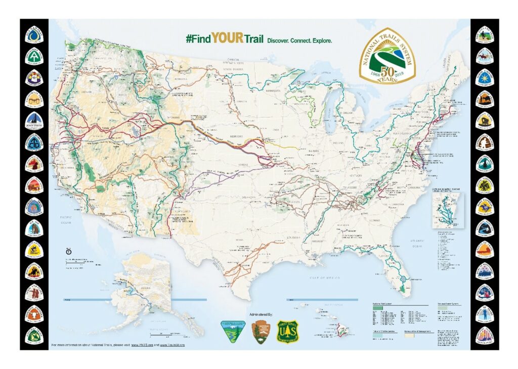
Figure 1 – National Trails System Map – Public Domain, National Parks Service
Hiking Trails & Historical Trails
Traveling long distance over surface streets post-TEOTAWKI may not be possible. In such times fear is causes towns to close themselves off as the parishes surrounding New Orleans did during Hurricane Katrina mentioned earlier. Sherriff’s departments blocked the freeways preventing both motorized and foot traffic on the freeways. They might be afraid of looters, disease, or just letting in more people than they can feed. Some towns may escort travelers on through and out the other end of town.
Where there are towns, there are people. Where there are people, there will be roadblocks. Where there are bad people, there will be ambushes. Heading off the larger lines of drift to the smaller ones will reduce the frequency of ambushes. Heading off the trails and cross country and traveling at night will reduce them even further.
Both Native Americans and explorers found that there are some big obstacles to navigating the U.S. If the Missouri River, the Continental Divide, or the Colorado River (and the catacomb of slot canyons surrounding it) or any of dozens of smaller obstacles stand between you and your destination, there are probably only routes through them. Historical trails, roads, highways, passes, fords, and ferries may provide the only safe way through them. Likewise, rail bridges, hiking trails, and old disused roads and railroads, and powerlines can provide passage or navigable trails.
Hiking Trails
All told, I counted some 18 trails over 1,000 miles in the U.S. and there are dozens upon dozens that run 100 miles or more. (Wikipedia, 2023) Some are part of the National Trails System, but many others are state trails. A great web of trails spans federal, state, county, and city lands. Chances are the combined trail system can help get you where you need to go.
Prepare by mapping routes out of town to bugout locations with friends, relatives, survival groups, or retreats. Get 1:24K scale USGS topographical maps for any area you may travel through on foot as well as other useful maps and information. Decide what you will bring, start backpacking legs of your bugout routes, and cache supplies and equipment you may need.
Just a few examples of our nation’s trails are:
- The 3,100-mile Continental Divide Trail spans from Mexico to Canada snaking up through New Mexico, Colorado, Wyoming, Idaho, and Montana. (Service, n.d.)
- The 2,650-mile Pacific Crest Trail runs from Mexico up the west coast of California, Oregon, and Washington to Canada. (PCTA.prg, 2023)
- The Great Western Trail runs 4,455 miles from Mexico to Canada by way of Arizona, Utah, Idaho, Wyoming, and Montana. (Wikipedia, Great Western Trail, 2023)
- The 6,875-mile Great Western Loop links the Pacific Crest Trail, the Pacific Northwest Trail, the Continental Divide Trail, The Grand Enchantment Trail, and the Arizona Trail accessing virtually the entire western U. S. (Wikipedia, Great Western Loop, 2024)
- The 5,057-mile American Discovery Trail is another trail that links several different trails to span the entire nation from coast to coast and has northern and southern routes through the center of the country. (Trail, 2024)
- The Eastern Continental Trail runs 4,400 miles from Florida up into Canada, not including portions that run over water to and from Newfoundland. This trail links several other trails including the Appalachian Trail. (Wikipedia, Eastern Continental Trail, 2022)
Rivers, Lakes, and Sea
While rivers and riverbanks are lines of drift, remote waterways should attract less attention than freeways, highways. and roads. Lewis and Clark and the mountain men used rivers where possible because they made it easier to transport heavy loads long distances.
A study of the National Trails map shows where major trails intersect with a few of the major rivers. To travel navigable rivers and lakes, you will need to study them. Many can be traveled by canoe, kayak, pack raft, or other small watercraft that can be cached nearby, packed or portaged overland from waterway to waterway. Preparation to travel safely by water requires specialized training, equipment, maps, and water flow tables or tide charts.
Following the 9-11 attacks, hundreds of thousands of people were evacuated from Manhattan Island by water. (Hanc, 2021) As a result, some who live or work on the island now have plans in place to evacuate by boat.

4-Wheel Drive Roads, Fire Roads, Old Highways
Every survivalist should also own current books of topographical maps of their state, state and national forest maps, and surrounding states as well as National Geographic Maps, road maps, and street maps of cities.
Most survivalists know that these maps must be combined with current satellite maps to show new construction and fire roads. What many don’t know is the value of historical maps that show where new highways were laid alongside old ones or old disused roads, and even historical trails used to run.
Infrastructure Rights of Way
Power lines, train tracks and canals have access roads and rights of way which are used to maintain them. They often all use the same common keys, easy to pick warded locks, or workers will even just close the padlock enough that they look like the lock is locked without really locking it to save time.
A cut fence or lock is evidence of a break-in and trespassing and it is best not to leave sign of your passing if it can be avoided.
Continued in Part 2
References
Hanc, J. (2021, Sep 9). 9-11 Flotilla Boats Evacuated 500,000 New Yorkers to Safety. Retrieved from smithsonianmag.com: https://www.smithsonianmag.com/history/911-flotilla-boats-evacuated-500000-new-yorkers-safety-180978614/
PCTA.prg. (2023). Discover the Trail. Retrieved from PCTA.org: https://www.pcta.org/discover-the-trail/
Service, U. F. (n.d.). Continental Divide National Scenic Trail. Retrieved from fs.usda.gov: https://www.fs.usda.gov/managing-land/trails/cdt
Trail, A. D. (2024). The Trail. Retrieved from discoverytrail.org: https://discoverytrail.org/the-trail/
Wikipedia. (2022, January 22). Eastern Continental Trail. Retrieved from wikipedia.org: https://en.wikipedia.org/wiki/Eastern_Continental_Trail
Wikipedia. (2023, October 4). Great Western Trail. Retrieved from wikipedia.org: https://en.wikipedia.org/wiki/Great_Western_Trail
Wikipedia. (2023, November 5). List of long-distance trails in the United States. Retrieved from wikipedia.org: https://en.wikipedia.org/wiki/List_of_long-distance_trails_in_the_United_States
Wikipedia. (2024, January 29). Great Western Loop. Retrieved from wikipedia.org: https://en.wikipedia.org/wiki/Great_Western_Loop
![The Tunguska Event [PODCAST]](https://survivalcove.com/wp-content/themes/mts_sociallyviral/images/nothumb-sociallyviral-featured.png)


